UttaraPedia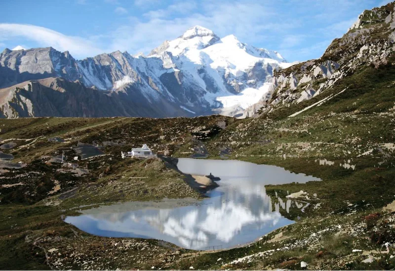
Some mountain journeys stay with you before you even reach the destination. Beyond Dharchula, the approach to Adi Kailash moves through a changing landscape: a road beside the river, villages on the slopes, then the open scale of the higher Himalayas.
For some travellers the purpose is darshan; for others it is the chance to see the mountains closely. Both interests have a place here. First, though, it helps to understand that Adi Kailash and Om Parvat are two different places.
Adi Kailash and the approach to Jolingkong
Adi Kailash is a sacred mountain in Uttarakhand’s Pithoragarh district, also known as Chhota Kailash. Its association with Shiva and Parvati and its resemblance to Mount Kailash in Tibet are central to its identity. The two mountains are distinct.
The approach through Kuti towards Jolingkong brings you into a high Himalayan setting. Parvati Sarovar, the temple and the surrounding mountains are central to the visit. When the water is still and the view clear, the lake can hold a reflection of the landscape.
Gauri Kund also belongs to the area’s sacred geography. Do not assume every nearby place has the same access: ask a local guide about walking, conditions and current permission for the particular visit.
Om Parvat: a shape revealed by snow
The Om Parvat viewing route heads from Gunji towards Nabhidhang via Kalapani. Against the darker mountain, snow creates the pattern associated with the sacred syllable Om.
The clear shape seen in photographs is not guaranteed on every visit. Snow cover, cloud and light change what is visible. Come prepared for a mountain landscape that has its own timing.
Understand where the routes divide
The usual approach begins through Dharchula and continues towards the Gunji area. From there, remember Kuti–Jolingkong for Adi Kailash and Kalapani–Nabhidhang for Om Parvat.
That distinction makes the geography much easier to follow. Give each visit its own time rather than treating the two as photographs taken at a single stop.
The villages deserve your attention too
It is easy to see the Vyas Valley simply as the road to a mountain. Villages such as Gunji, Nabi and Kuti give the journey a different scale: homes, daily routines and conversations alongside the sweeping views.
If you stay locally, ask your hosts about their village. Seek permission before photographing people or homes. A homestay and local food can add depth to the visit when you respect residents’ privacy and the practical limits of remote accommodation.
Leave room to look
After darshan, pause if conditions and your schedule allow. Watch a summit emerge from cloud, light move across a slope, or wind disturb the water. These small changes are part of the experience.
For photographs, a wide view can show how the road sits within the mountains; a tighter frame can pick out a ridge or texture. Stop only where it is safe, avoid obstructing traffic and follow restrictions around sensitive locations.
Watch the journey with PopcornTrip
See the road, mountains and setting in PopcornTrip’s journey film. Footage records conditions at the time of filming; confirm access and permissions for your own travel dates. YouTube ↗
Turn the idea into a considered plan
This is a remote, high-altitude border region. Road access is only one part of preparation. Understand permissions, health considerations, accommodation and current conditions before committing to dates.
Continue with our practical yatra planning guide for route decisions, questions to ask before booking and packing essentials. Leave enough flexibility to enjoy the places between the viewpoints.